strawberry hill Residents’ Association


All text, images and design © Copyright 2014 Strawberry Hill Residents’ Association, except where noted.
For all residents of Strawberry Hill
The Council’s Village Plan for Strawberry Hill, as published in 2012, defined a smaller village than that which residents have been used to for more than 100 years.
Strawberry Hill has never been a administrative area -
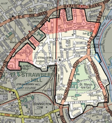
When this association was formed in 1965, a precise boundary was defined (see Membership) for the twin purposes of confining membership to those homes which consider themselves to be in Strawberry Hill and to limit the distribution of the Bulletin to those homes. This has been the undisputed boundary since then.
The Council’s Plan excluded about 800 homes out of the 2450 homes in our area and placed them in the Twickenham ‘village’. These roads are in the Northern and Western part of the area (shown in red on the map below, which also shows the SHRA-
We are delighted to report that the Council agreed to our complete proposal and Strawberry Hill village remains the same.
Village Plan